# RapidCrops
## Data coverage
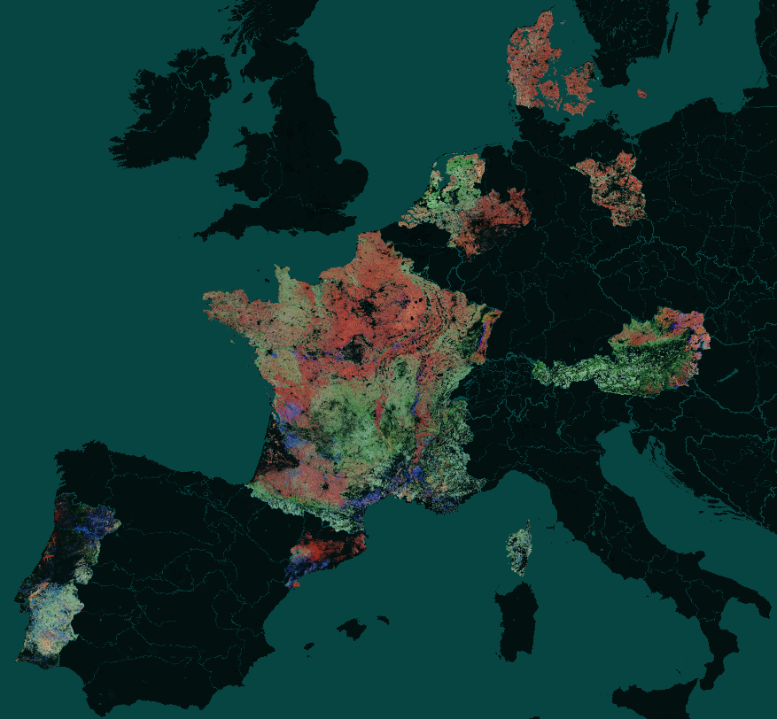 Dense temporal coverage (2018-2022) across seven countries:
- Austria
- Denmark
- Spain (partial coverage in Catalonia only)
- France
- Germany (partial coverage in Brandenberg, Nordrhein Westfalen & Lower Saxony)
- Netherlands
- Portugal
Additional years of coverage are included for:
- Germany (2023 & 2024)
- France (2023)
- Netherlands (2023 & 2024)
Datasets are published in two forms:
1. "National": National datasets are provided individually for each year of coverage.
2. "Combined": All national datasets are combined into a single partitioned (by country) dataset for a given year.
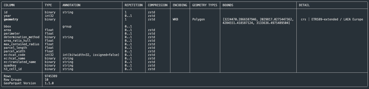
## Data structure
Because all data resides within Europe, boundary geometries are all provided in `EPSG:3035`.
See below an example GeoParquet schema for the France 2020 dataset:
Dense temporal coverage (2018-2022) across seven countries:
- Austria
- Denmark
- Spain (partial coverage in Catalonia only)
- France
- Germany (partial coverage in Brandenberg, Nordrhein Westfalen & Lower Saxony)
- Netherlands
- Portugal
Additional years of coverage are included for:
- Germany (2023 & 2024)
- France (2023)
- Netherlands (2023 & 2024)
Datasets are published in two forms:
1. "National": National datasets are provided individually for each year of coverage.
2. "Combined": All national datasets are combined into a single partitioned (by country) dataset for a given year.
## Data structure
Because all data resides within Europe, boundary geometries are all provided in `EPSG:3035`.
See below an example GeoParquet schema for the France 2020 dataset:
 ## Usability and efficiency
Redundant vertices were removed from the boundary polygons with a tolerance of 20cm to protect the integrity of the parcel.
This resulted in a >25% reduction in the number of vertices, allowing for more efficient spatial queries.
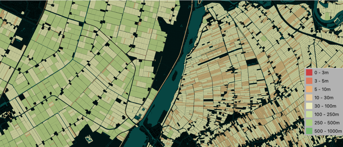
## Assessing suitability for combining parcels with EO products
Identifying parcels from which clean pixels can be obtained from satellite imagery depends on both the size of a parcel and the regularity of its shape.
RapidCrops provides attributes to help quantify these properties:
- `parcel_width`: The length of the shortest edge on the parcel boundary's minimum rotated rectangle
- `area_ratio_hull`: The ratio between the area of the parcel boundary, and that of its convex hull
- `max_contained_radius`: The radius of the parcel boundary's maximum inscribed circle
Knowing this can help to filter out parcels from which meaningful analysis cannot be performed, or to help explain variation in performance across parcels.
These metrics can be used to identify suitable parcels for analysis by a given EO sensor, as highlighted below:
## Usability and efficiency
Redundant vertices were removed from the boundary polygons with a tolerance of 20cm to protect the integrity of the parcel.
This resulted in a >25% reduction in the number of vertices, allowing for more efficient spatial queries.
## Assessing suitability for combining parcels with EO products
Identifying parcels from which clean pixels can be obtained from satellite imagery depends on both the size of a parcel and the regularity of its shape.
RapidCrops provides attributes to help quantify these properties:
- `parcel_width`: The length of the shortest edge on the parcel boundary's minimum rotated rectangle
- `area_ratio_hull`: The ratio between the area of the parcel boundary, and that of its convex hull
- `max_contained_radius`: The radius of the parcel boundary's maximum inscribed circle
Knowing this can help to filter out parcels from which meaningful analysis cannot be performed, or to help explain variation in performance across parcels.
These metrics can be used to identify suitable parcels for analysis by a given EO sensor, as highlighted below:
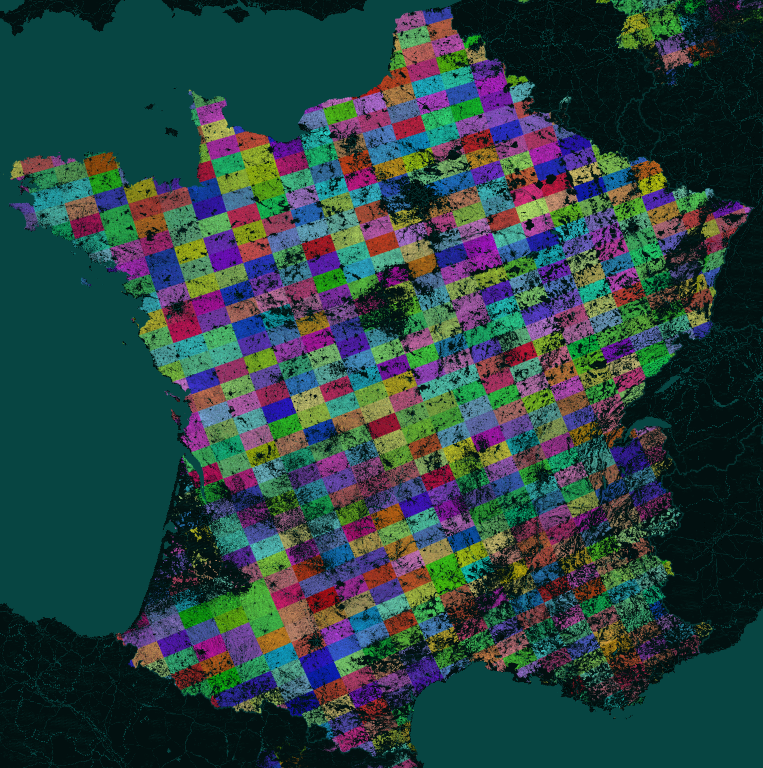
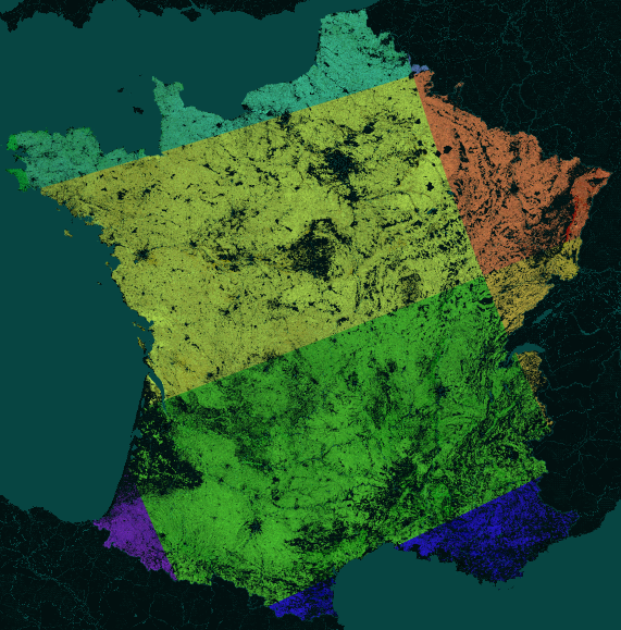
 ## Facilitating spatial stratification
Grid cell IDs from two popular spatial gridding systems (Quadkey & H3) are included for each boundary to allow for spatially-stratified sampling. The gridding systems are hierarchical and coarser grid resolutions can be derived form the values provided according to the user’s need.
Below is the quadkey spatial gridding at the resolution provided:
## Facilitating spatial stratification
Grid cell IDs from two popular spatial gridding systems (Quadkey & H3) are included for each boundary to allow for spatially-stratified sampling. The gridding systems are hierarchical and coarser grid resolutions can be derived form the values provided according to the user’s need.
Below is the quadkey spatial gridding at the resolution provided:
 But coarser resolution gridding can be derived by reading a subset of the leftmost characters in the key:
 ## Accessing the data
```python
import geopandas as gpd
url = "s3://planet/rapidcrops/national/AUT/rapidcrops_2018_aut.geo.parquet"
# Retrieve a full dataset
df = gpd.read_parquet(url)
# OR, filter the dataset on a bbox for faster retrieval
df = gpd.read_parquet(url, bbox=bbox)
```
## Underlying data licenses
The data is made available subject to the licenses associated with the underlying source datasets. No additional limitations or conditions are applied. See below for links to the underlying license information for each source dataset:
| Source dataset | Dataset license |
|-----------------------|-----------------------|
| Austria | [INSPIRE public access license](http://inspire.ec.europa.eu/metadata-codelist/LimitationsOnPublicAccess/noLimitations) & [CC-BY-AT 4.0](https://creativecommons.org/licenses/by/4.0/) |
| Denmark | [INSPIRE public access license](http://inspire.ec.europa.eu/metadata-codelist/LimitationsOnPublicAccess/noLimitations) & [INSPIRE no conditions](http://inspire.ec.europa.eu/metadata-codelist/ConditionsApplyingToAccessAndUse/noConditionsApply) & [CC0 1.0 Universal](https://creativecommons.org/publicdomain/zero/1.0/deed.en) |
| France | [Custom open license](https://www.etalab.gouv.fr/wp-content/uploads/2014/05/Open_Licence.pdf) |
| Germany | Custom open licenses: [NRW](http://dcat-ap.de/def/licenses/dl-by-de/2.0), [Brandenberg](https://www.govdata.de/dl-de/by-2-0), [LS](http://dcat-ap.de/def/licenses/dl-by-de/2.0) |
| Netherlands | [INSPIRE public access license](http://inspire.ec.europa.eu/metadata-codelist/LimitationsOnPublicAccess/noLimitations) & [INSPIRE no conditions](http://inspire.ec.europa.eu/metadata-codelist/ConditionsApplyingToAccessAndUse/noConditionsApply) & [Dutch creative commons license](http://creativecommons.org/publicdomain/mark/1.0/deed.nl) |
| Portugal | [CC BY 4.0](https://creativecommons.org/licenses/by/4.0/) |
| Spain | [Custom open license](https://administraciodigital.gencat.cat/ca/dades/dades-obertes/informacio-practica/llicencies/#limitacio-de-responsabilitat) |
## Suggested citation
```
Holden, P., Davis, T., Holmes, C., Senaras, C., & Wania, A. (2025). RapidCrops: A pan-European label dataset for large-scale crop classification (v1.0) [Data set]. Zenodo. https://doi.org/10.5281/zenodo.15166359
```
In BibTeX format:
```
@dataset{rapidcrops,
title = {RapidCrops: A pan-European label dataset for large-scale crop classification},
publisher = {Zenodo},
doi = {https://doi.org/10.5281/zenodo.15166359},
year = {2025},
urldate = {},
author = {
Holden, Piers and
Davis, Timothy and
Holmes, Christopher and
Senaras, Caglar and
Wania, Annett
},
version = {1.0},
}
```
## Accessing the data
```python
import geopandas as gpd
url = "s3://planet/rapidcrops/national/AUT/rapidcrops_2018_aut.geo.parquet"
# Retrieve a full dataset
df = gpd.read_parquet(url)
# OR, filter the dataset on a bbox for faster retrieval
df = gpd.read_parquet(url, bbox=bbox)
```
## Underlying data licenses
The data is made available subject to the licenses associated with the underlying source datasets. No additional limitations or conditions are applied. See below for links to the underlying license information for each source dataset:
| Source dataset | Dataset license |
|-----------------------|-----------------------|
| Austria | [INSPIRE public access license](http://inspire.ec.europa.eu/metadata-codelist/LimitationsOnPublicAccess/noLimitations) & [CC-BY-AT 4.0](https://creativecommons.org/licenses/by/4.0/) |
| Denmark | [INSPIRE public access license](http://inspire.ec.europa.eu/metadata-codelist/LimitationsOnPublicAccess/noLimitations) & [INSPIRE no conditions](http://inspire.ec.europa.eu/metadata-codelist/ConditionsApplyingToAccessAndUse/noConditionsApply) & [CC0 1.0 Universal](https://creativecommons.org/publicdomain/zero/1.0/deed.en) |
| France | [Custom open license](https://www.etalab.gouv.fr/wp-content/uploads/2014/05/Open_Licence.pdf) |
| Germany | Custom open licenses: [NRW](http://dcat-ap.de/def/licenses/dl-by-de/2.0), [Brandenberg](https://www.govdata.de/dl-de/by-2-0), [LS](http://dcat-ap.de/def/licenses/dl-by-de/2.0) |
| Netherlands | [INSPIRE public access license](http://inspire.ec.europa.eu/metadata-codelist/LimitationsOnPublicAccess/noLimitations) & [INSPIRE no conditions](http://inspire.ec.europa.eu/metadata-codelist/ConditionsApplyingToAccessAndUse/noConditionsApply) & [Dutch creative commons license](http://creativecommons.org/publicdomain/mark/1.0/deed.nl) |
| Portugal | [CC BY 4.0](https://creativecommons.org/licenses/by/4.0/) |
| Spain | [Custom open license](https://administraciodigital.gencat.cat/ca/dades/dades-obertes/informacio-practica/llicencies/#limitacio-de-responsabilitat) |
## Suggested citation
```
Holden, P., Davis, T., Holmes, C., Senaras, C., & Wania, A. (2025). RapidCrops: A pan-European label dataset for large-scale crop classification (v1.0) [Data set]. Zenodo. https://doi.org/10.5281/zenodo.15166359
```
In BibTeX format:
```
@dataset{rapidcrops,
title = {RapidCrops: A pan-European label dataset for large-scale crop classification},
publisher = {Zenodo},
doi = {https://doi.org/10.5281/zenodo.15166359},
year = {2025},
urldate = {},
author = {
Holden, Piers and
Davis, Timothy and
Holmes, Christopher and
Senaras, Caglar and
Wania, Annett
},
version = {1.0},
}
```